You can read about the first leg of my trip, Days 1-4, here.
I realized it was probably for the best that I was not on trail. In addition to the driving winds and rain, there was lightning.

This storm literally lasted all day and into the night.
On a clear day, this overlook spot has a great view (probably), but not that day.

The fog began to lift as we hiked along that morning. We stopped to eat lunch somewhere between Black Fork Mountain Shelter and Foran Gap. There was a section of the trail where the trail was in a deep groove between piles of rocks for several yards. There were enough rocks that were flat-ish that we could sit, so that's where we took a break and ate some snacks and lunch.
This is one of those examples in the FarOut app where the symbols don't necessarily map to reality. In the app, the falls is designated as a year round water source. We were there a day after a long rain. There was a trickle of falls. It wasn't spectacular. If it was the only source of water, we could have collected and filtered there, but it wasn't great. Cedar Creek is marked as a seasonal source, but it was flowing and it was a great source of water.

This section of trail was much less rough than the sections of trail in Oklahoma and it seemed like the trail was easier to follow. It could be that after the rain, the leaves got matted down more so the groove of the path was more visible, but whatever the case, we were glad that navigating was not difficult in this section. Elevation changes weren't huge on this day either, which also helped.
We stopped for another break a couple of miles after the water cache. There was a campsite with logs where we could sit. We also found another cache of water with other treats (trail magic) at mile 88.3. We had Gatorades and a snack size candy bar each. It was a nice reward near the end of a very long day on trail.

One last thing to note about this section is the complete lack of natural water sources between Foran Gap and Brushy Creek Mountain. Cedar Creek is before Foran Gap Shelter at mile 67.7 and the next source is Big Brushy Creek at mile 94.5 after Brushy Creek Mountain Shelter. That's almost a 27 mile gap from one source to the next. I'm grateful for the trail angels who helped us by caching water there, but I'm also wondering why the trail doesn't dip into a valley somewhere between those points where there water could be found. Surely there would be some water somewhere along that path. Maybe it's private land? It doesn't look like it on the maps though.


We stopped for lunch at Fiddler Creek Shelter. It's a nice shelter. It's funny, many Android users are familiar with prompts from Google asking for information about public locations they have visited. If you go to a store, for example, Google will say "Care to answer a few questions about this place?" and it will ask things like, is there a handicapped entrance or parking, is there a fee to go there, can you buy food, etc. I got that prompt when we stopped at the Fiddler Creek Shelter.
The trail shelters on the OT are essentially three walls and a roof, with a covered porch area. I was curious what kinds of questions Google was going to ask related to the shelter. Here are a few examples I can recall.
We got to Suck Mountain Shelter just before sunset. Sunset at the top of the mountain was beautiful. The sky was also full of stars that night. But it was a windy and rather cold night in that shelter.

The mileage was lower this day than the previous, but climbing elevation was almost 7000 feet. That was more than any other day on this trip. It was really three decent sized mountains. The trail was mostly flat and not rocky through this section though. That made things easier.

Those climbing elevation numbers were still relatively large, though I think the climbs didn't feel as difficult toward the end as they did at the beginning of the trip. The trail in this section was easy to follow and wasn't very rocky, which was nice.

I'm pretty sure those toenails are going to fall off eventually.

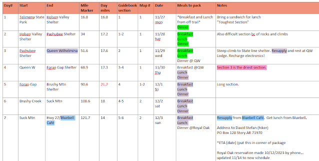
This post will recount my trip on the Ouachita Trail from Mile 51.5 at Queen Wilhelmina Lodge to Mile 121.7 at the Highway 27 trailhead.
Day 5: Thursday 30 Nov 2023
Zero Day
I had not planned to take a zero day on this trip. But looking out my window that morning...
I realized it was probably for the best that I was not on trail. In addition to the driving winds and rain, there was lightning.

This storm literally lasted all day and into the night.
So what did I do that day? First, I changed rooms at the lodge. When I checked in, I had splurged a bit and got a room with a jet tub. I'm not generally someone who loves a soak in a bathtub, but I will say, it did wonders for my aching muscles and grimy body to have a soak and some Jacuzzi jets in a steaming hot bath. Having said that, I didn't really want to spend that money for two nights. Mrs. Gavagai told me to just stay put in the Jacuzzi room because it was too much trouble to pack everything up and change rooms, but I pointed out the fact that every single day when I'm on trail, that's what I do; pack up everything and carry it to the next spot. The difference here is I only had to walk down some stairs and down a short hall, not 15-20 miles and up and over mountains. Haha.
Trail Friends
It's really past time that I introduced my trail friends. The two ladies who caught up with me go by Tater and Andy. We had breakfast together that morning. After breakfast, we did a short one mile loop hike in rain gear around the top of Rich Mountain with a group of Andy's friends who were also at Queen Wilhelmina State Park that day.
 |
| Andy on the left, Gavagai in the middle, Tater on the right |
On a clear day, this overlook spot has a great view (probably), but not that day.
The rest of the day was really about resting and recovering. On my right foot, I had a burst blister on my big toe. The nail on both my second toes (the piggy that stayed home) had been bashed by rocks to the point that the nail had been unmoored from the cuticle. The skin was still holding on, but they were tender to the touch and it felt like the nail was floating free from the nailbed. While I was at the Winding Stair Shelter with Tater, Andy, and their other friend Trail Boss, I had taken the time in the morning before I left to bandage and tape up my affected toes, but the damage had really been done. The bandages and tape helped reduce the pain though. At the lodge, I was letting them breathe before the next segment.
 |
| This is bad, but it gets worse. |
That afternoon I watched some episodes of Mythbusters and took a glorious nap.
Planning Ahead
I wasn't sure what Tater and Andy were thinking with regard to their trip and whether or not I fit in. They were clearly capable of doing some longer days, but I had 3 days of big miles planned ahead. I was determined to stick to my schedule as much as possible because I needed to get back to work.
We grabbed dinner together than night at the lodge. During dinner, they were talking about how far they were thinking about hiking the next day and when they would start. I told them I planned to do the 17.6 miles to Foran Gap Shelter and that I was going to start as early as possible.
I had a schedule lined out for each day on the trail. Here is a screenshot of the kinds of details I put into my plan.

My next four days on the trail would be
- 17.3 miles to Foran Gap Shelter
- 21.7 miles to Brushy Mountain Shelter
- 18 miles to Suck Mountain Shelter
- 14 (actually 13) miles to Highway 27 for the next resupply at the Blue Bell Cafe and Country Store
My general thinking was that Andy and Tater were welcome to come along if they wanted, but I was going to stick to my plan unless I was unable to do so.
Day 6: Friday 1 Dec 2023
At dinner the night before in the QW lodge restaurant, I ordered my dinner, but in addition to the sandwich that I ate for dinner that night, I also ordered a chicken quesadilla, which I stuck in the fridge to eat for breakfast on Friday morning. I ate my quesadilla, took a shower and packed up. I was ready to go before 6:30 am, but when I walked outside, the fog was so thick, I couldn't see anything beyond the pavement on the drive around the lodge. I decided to wait a few more minutes until the sun started to light the horizon a bit. When I went back into the lobby, Tater and Andy were at the front desk checking out.
We all departed from QW around 6:45 that morning.
One big benefit of the rain was that it recharged the rivers, creeks and streams on the mountains. From Queen Wilhelmina to Brushy Creek is supposed to be the driest section of the trail, so I was optimistic that water would be less scarce after the rain.

One of the neat things about our hike that morning after leaving QW, there were several rocky places along the trail where we could hear water rushing down the mountain beneath the rocks we were walking on. In a couple places, we could see it just below the rocks. In other places, we couldn't see the water at all. In one location, the water was very deep, but rushing in a big stream beneath us. It was loud, but also a low rumble. When we first heard it, we thought it was a plane in the sky, but it was just water rushing deep beneath us. It was kind of eerie.
After lunch, we hiked on. We were still carrying the water we filled up on from QW. Even though there had been a few crossings where we could have filled up, but they were so close to QW that we didn't need water at that point. We were running low by the time we reached Cedar Creek, but there was plenty of water at Cedar Creek that day.
 |
| Last water sources before the shelter ...and for miles ahead |
The falls
People can leave comments to let others know what they found at each of those locations when they passed through. The falls here is consistently either barely trickling or bone dry and Cedar Creek is relatively dependable. I'm sure there is a way this kind of thing can be corrected in the app, but I haven't tried. I may look into it.
In any case, we cameled up and filled up so we would have water at camp and for the next leg of our trip. Saturday was going to be the longest day so far and, looking ahead on the app, there were not many water sources to be found.
Cedar Creek
A New Friend
When we rolled up to Foran Gap Shelter, we discovered there was another hiker there set up to spend the night already. Foran Gap Shelter would host four hikers that night. Our new friend's name was Bill. Bill was hiking the other direction on the trail. He had hiked through the storm the day before and all his day clothes were soaked. He had them spread around the shelter and hung up on shelves, hoping they would dry out.
 |
| Left to right, Bill, Andy, Tater, Me |
Bill's plan for the next day was to do the same section of trail we had just come from and we were going to hike where he just came from, so we exchanged information about what to expect over the upcoming miles.
We learned from Bill that the next section was high and dry. There were a handful of places with muddy puddles (not ideal for getting water because the suspended silt and mess clogs your filter and reduces the lifespan of your filter). However, there were a couple of places along the trail where water had been cached for hikers by trail angels. This was valuable information. We were grateful to Bill.
We ate our dinners and went to bed, planning to rise before dawn to get an early start for our 21.7 mile day to Brushy Mountain Shelter. I also learned that night that my sleeping pad patch had a slow leak. Over the course of about 30 minutes after filling it, I could feel a butt cheek touching the floor of the shelter, then slowly more, then a thigh, and so on, until a few hours in, most of my body weight was resting on the hard wooden floor of the shelter. Another night of sleep that wasn't ideal, but I did sleep. Hard long days on the trail do make sleep come more easily. This night wasn't particularly cold and there wasn't much wind. That also helped.
Data
We hit the trail at 6:43 am from Queen Wilhelmina in the fog and hiked 17.7 miles. Our pace was 1.83 mph.

Day 7: Saturday 2 Dec 2023
We started Day in fog stew. It was thick! We were fortunate in that the trail was a well defined path that was relatively easy to follow. The mist and fog were so thick that the forest around us was dripping. We had a climb that morning from Foran Gap, but we soon found ourselves on the mountain above the fog. We looked out over the mountain valleys around us and they were covered with a cloud blanket with a few peaks in the distance popping up out of the white sheet of clouds and the sun was now peaking up above the horizon. I'm not big on mountain overlooks along the trails (I find the topography of the valleys with the rock formations that have been cut away though millennia of water and floods to be more interesting), but this was a truly stunning panoramic view.
 |
| Thick morning fog, Andy lead the way with me right behind. Nice photo Tater! |
 |
| A sea of clouds and fog covering the valleys. A few peaks and ridges above the clouds in the distance. |
This was a very long day, and aside from those early views and the fact that we were a little chilly for most of the morning (Andy and Tater kept hoping for sunlight, but it seemed we were on the north side of the mountains in shade for most of the day).
 |
We stopped for lunch near Turner Gap Shelter. The Shelter was on a spur that lead downhill for about a tenth of a mile, and we didn't feel like going that extra distance that day, but there was a relatively flat spot near the junction between the trail and the trail spur that lead down to the shelter, so we stopped there and ate and rehydrated.
Foran Gap Shelter is at mile 69 and the first water we came to was at mile 84.8 near a forest service road. There were 2.5 gallons of water there in jugs and we needed it. We drank and filled up. The water was depleted from that cache when we were finished. I posted a thank you to the trail angels who dropped the cache on the Ouachita Trail facebook page and also let them know that we emptied what was there between the three of us.
 |
| I took this photo while we were stopped for a break to see if I looked as tired as I felt. |
We rolled into the shelter at Brushy Creek Mountain at 5:28 pm that night at mile 90.4. We were exhausted, but proud that we made the 21.4 mile day and got to our shelter before dark. We ate dinner, made camp, and we were all in bed ready for sleep around 7 pm that night. The next day was another early start and 18 miles.
Data
On Day 7 we hiked for 11 hours and 9 minutes for 21.4 miles at a pace of 1.92 mph. In spite of multiple short stops, we kept a decent pace that day. Climbing elevation was also above average, so all things considered, we did very well. Way to go Andy and Tater. 😊

One last thing to note about this section is the complete lack of natural water sources between Foran Gap and Brushy Creek Mountain. Cedar Creek is before Foran Gap Shelter at mile 67.7 and the next source is Big Brushy Creek at mile 94.5 after Brushy Creek Mountain Shelter. That's almost a 27 mile gap from one source to the next. I'm grateful for the trail angels who helped us by caching water there, but I'm also wondering why the trail doesn't dip into a valley somewhere between those points where there water could be found. Surely there would be some water somewhere along that path. Maybe it's private land? It doesn't look like it on the maps though.
Day 8: Sunday 3 Dec 2023
Another early start, though an 18 mile day now seemed like a light carry. This day also promised a number of water sources along the trail, so water scarcity was not going to be a big problem for us.
We got started just before 6:30 am. The first stop would be Big Brushy Creek Campground. At the campground there were pit toilets, trash bins, and water! It felt almost like walking back to civilization! Getting rid of our trash lightened our load. Using toilets instead of squatting in the woods was also a welcome novelty. We rehydrated and filled up.
The End is Nigh
Even back at Queen Wilhelmina, I was having thoughts about going home and being finished with my trip, but at that time, I wasn't quite ready to pull the plug. I believe it was on this 8th day of my trip that my urge to be finished solidified in my mind and I had conversations with Mrs. Gavagai about arrangements to terminate when I reached the halfway point. After filling our waters, I hiked ahead of my two trail companions and made a phone call to my wife. By the time we reached our lunch on this day, I believe we had a plan in place and I let Andy and Tater know that I would not be continuing beyond Highway 27.
It wasn't that I didn't think I could keep going physically, though I was certainly tired, achy, and sore. It was just enough days on the trail for me. I wanted to be home with my wife.


 |
| I think this was Fiddler Creek...? Me, Andy, Tater, left to right. |
This might be a good time to explain what these shelters are like. I haven't really shared any good photos here.
 |
| Fiddler Creek Shelter |
The trail shelters on the OT are essentially three walls and a roof, with a covered porch area. I was curious what kinds of questions Google was going to ask related to the shelter. Here are a few examples I can recall.
- Would this be a good result for someone searching for "Mountain Cabin"?
- Is there a public restroom?
- Are there picnic tables? (most of the shelters do have a picnic table)
- Would this be a good place for kids birthday parties?
That last question really made me laugh when I read it. I pictured a parent explaining to their young child that they didn't understand why none of the children they invited to their party didn't show up. The shelter is only 20 miles of dirt forest road, then a mile hike to the shelter. Just as good as Chuck E Cheese!
 |
| Sunset on top of Suck Mountain |
We got to Suck Mountain Shelter just before sunset. Sunset at the top of the mountain was beautiful. The sky was also full of stars that night. But it was a windy and rather cold night in that shelter.
Before dinner that night, I attempted to apply another patch over the top of my previous patch, hoping that the leak was there. No luck, unfortunately. The pad still leaked on me. I blew it up two or three times in the night, but this was my last night on the trail.
Shark Fight
Sometime in the middle of the night, I had a dream. I dreamt that I was being dragged through the water, I guess I was in the ocean. When I looked up, I saw that it was a shark that was pulling me through the water, swimming away from me. It occurred to me that I must be hanging onto the shark's tail, and at that moment I decided to let go of the shark. The shark turned around and started swimming right toward me. Without thinking, I kicked hard at the shark ...and in real life. I woke up having kicked out and down and my foot hit the wood floor of the shelter, THUD! I wasn't sure if I woke Andy or Tater at the time, but I think they both stirred. I had earplugs in, so I didn't hear them say anything, but I whispered an apology "sorry" hoping not to disturb their sleep if I hadn't already done so.
I'm thinking that maybe the sound of the wind whipping around the shelter made my brain think about ocean waves or something. 🤷
This story bleeds into the next day, but I'll finish it on the entry for this day. So Monday, at some point while we were hiking along, I told Andy and Tater about my dream and asked if they heard my big thud the previous night. They both laughed. Andy said when it happened she had asked if I was okay, but all I said was "sorry". I hadn't heard her ask if I was okay because of my earplugs I guess. Dreams are so funny sometimes. It's good that we didn't sleep close together because I could have hurt someone.
Data
We hiked 18 miles in 10 hours and 20 minutes at a pace of 1.74 mph.

The mileage was lower this day than the previous, but climbing elevation was almost 7000 feet. That was more than any other day on this trip. It was really three decent sized mountains. The trail was mostly flat and not rocky through this section though. That made things easier.
Day 9: Monday 4 Dec 2023
Most mornings I had been making freeze dried egg meals of one kind or another. On this morning, freeze dried eggs did not appeal to me. I had a couple of breakfast bars, packed up my bag and we were ready to walk. It was a short day, only 13.1 miles of trail between Suck Mountain Shelter and Highway 27.
The halfway point on the trail is technically 111.5, but the trailhead at Highway 27, at mile 121.7 is the functional halfway point for the Ouachita Trail. The Highway 27 trailhead is just north of Story, Arkansas on the highway, and in Story there is a business called the Blue Bell Cafe and Country Store. The owner of the Blue Bell's name is Lori, and Lori offers shuttle resupply service to OT hikers. Her support of the trail is way above and beyond, and if she retires and no one takes up her role, it will have a huge impact on the trail and hikers' experience on the OT.
 |
| Mandatory selfie at the halfway marker. Left to right; Andy, Gavagai, Tater |
Lori from the Blue Bell was going to pick us up from the Hwy 27 trailhead. We coordinated with her so she would know what time we expected to be there. I gave her a call around 10 am to let her know that we were on schedule to be at the trailhead between 1:30 and 2 pm. The trail that morning was generally easy to follow and not too terribly taxing. Weather was cool, but pleasant. I don't think we needed to stop for water that day, but we did take a couple of breaks along the way. The first stop was for snacks and to have a drink. The second break was a bit longer at Story Creek Shelter.
Story Creek Shelter is in a very pretty location. It's just off the trail in a valley. There is a spring and a creek nearby. After spending the night on the top of a super windy mountain, the valley seemed so quiet and peaceful. When I threw my pack back on, Tater and Andy were somewhat disappointed that we had to leave, but I didn't want Lori to have to wait on us.
The last segment of the trail that day went through an area of the Ouachita National Forest where the Forest Service had conducted a prescribed burn at some point in the last year or two. We could see singe marks on the trunks of trees and some other evidence of the burn, but the forest was springing back to life all around. It was one of the most lush and green areas we had seen on the trail. There were grasses and flowers and smaller trees and shrubs all around. I'm sure it looked a bit desolate for a while after the burn, but it was beautiful when we passed through.
Story and Mount Ida
We walked out of the forest to the Hwy 27 trailhead around 1:31 pm. Lori pulled up just a few minutes later. We were very glad to see her. We threw our packs in the back of her truck and climbed in the cab. Lori drove us to the Blue Bell where she gave us our resupply boxes and we ordered lunch.
 |
| Me, Andy, Tater at the Blue Bell |
Meanwhile, Mrs. Gavagai was finishing up her day at work and getting ready to make the drive to come and get me. Andy and Tater would be staying the night at a local inn (where I had also planned to stay) located just south of Story in a town called Mount Ida.
 |
| Gavagai, Andy, and Tater left to right at Royal Oak Inn |
We ate a delicious lunch from the Blue Bell Cafe, and after lunch, Lori drove us to the inn. Andy and Tater checked in and I waited there for Mrs. Gavagai. She arrived around 4:30 and took me home.
Data
On this final day, we started hiking at 7 am, we hiked 13.1 miles. That distance took us 6 hours and 40 minutes and we traveled an average of 1.96 mph.

Those climbing elevation numbers were still relatively large, though I think the climbs didn't feel as difficult toward the end as they did at the beginning of the trip. The trail in this section was easy to follow and wasn't very rocky, which was nice.
Epilogue
It's been almost a week since I left the trail. In hindsight, I think I made the right choice. The long mile days were not sustainable for me for the whole length of the trail, and I legitimately needed a couple of days after returning to recover and rest. If I had finished the full trail, it would have taken me beyond the days I had allotted to be away from work just to finish the trail, and I might have needed more that two days to recover from the fatigue and strain of the last hundred miles.
I lost about 9 lbs over the course of the hike. My muscles have recovered, but the affected toe nails look worse now than they did at Queen Wilhelmina.

I'm pretty sure those toenails are going to fall off eventually.
Friends and family know that just before I left for this trip, my orthopedic doctor diagnosed me with a torn meniscus in my right knee. People were wondering whether that knee gave me any problems on the trail because it has caused problems for me on the pickleball courts recently. The answer is no, it really didn't give me any serious pain on the trail. I would say that is probably due to the fact that I got a steroid shot in that knee a week before I left for my trip, and I think another factor is that the issues seem to be related more to lateral movements than going straight forward or stepping up or down. Pickleball involves a lot of lateral movements, so that's where I was experiencing stress and pain with that knee.
The Eastern Half
I do intend to finish the rest of the OT in the coming months, but I will do it in a series of shorter section hikes over the course of weekends. I have learned that 3-4 days in the woods is plenty for me at one time. I have also learned that rough trail can be brutal to your feet and I probably should have slowed my pace more on the super rocky sections of the trail and resolved to do fewer miles on those days.
I'm glad I tried my hand at a long through hike. It was a good experience, and I feel like I learned a lot.
Trail Friends Epilogue
Andy and Tater continued on the trail, determined to finish the whole thing. As I write this, they are wrapping up the last section. I suspect they will finish either today or tomorrow. They are two strong and determined women. Way to go ladies. 🙂
Update: They finished Dec 12th. Tater and Andy are hardcore. 👏
 |
| OT eastern terminus sign at Pinnacle Mountain State Park. Andy on the left, Tater on the right. |
My journey on the OT continues here from Hwy 27 to Hwy 7.
For my Lessons Learned post, click here.
Thanks for stopping by,
Gavagai

Comments
Post a Comment